You may have heard it mentioned from time to time around the subject of the Smoky Mountains hiking trails and might have even wanted to take a gander into it yourself at some point – the Appalachian Trail is a part of our Smoky Mountain National Park and we get both visitors to the Smokies who are interested in the AT, as well as visitors to Gatlinburg and Pigeon Forge who came directly FROM the AT. This segues into the fact that the Smoky Mountains are part of the Appalachian Trail, instead of the other way around that it usually is for hiking trails in our region.

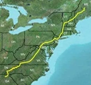
For those not in the know, the Appalachian Trail is sort of the crowning achievement of hiking in the Appalachian chain of mountains because it’s a “trail” that is, get ready, 2,200 miles that extends from Springer Mountain, Georgia, to Mount Katahdin, Maine. That’s 2,200 miles of walking in the woods from the deep South to the deep… North? It’s practically walking half the width of the country and while it is definitely not a hiking challenge for casual hikers, we felt it was an awe-inspiring part of the Smokies worth writing a blog post for all the same.
Who knows? It might be right up your alley!
From Hikinginthesmokys.com:
“The Appalachian Trail, also known as the A.T., runs for more than 71 miles through Great Smoky Mountains National Park. It enters the park from the south at Fontana Dam, and exits in the northeast at Davenport Gap. The highest point anywhere along the 2180-mile trail is 6625 feet, at Clingmans Dome. The trail also passes by other notable landmarks in the Smoky Mountains, such as Charlies Bunion, Rocky Top and the historic stone fire tower atop Mt. Cammerer.
 It usually takes 7 days for most people to hike the Smoky Mountains section of the Appalachian Trail. If you don’t have that much time, this hike can easily be shortened by using Newfound Gap or Clingmans Dome as a mid point. Either of these sections of the A.T. can be done in 3 or 4 days. Of course, since these are all one-way trips, you’ll have to arrange for some sort of transportation at the end of your hike.
Hikers follow along the Appalachian Trail with the help of a system of “blazes” painted on trees, posts, and rocks. Although there are some local variations, most hikers grasp the system fairly quickly. Above tree-line, or in places where snow or fog can obscure paint marks, wooden posts and rock piles, known as “cairns,” are used to identify the route.
Drinking Water
The Park Service recommends that all drinking water should be treated as a result of the presence of Giardia lamblia in park waters. If the parasite is ingested you could end up with an intestinal disorder that doesn’t appear until after your trip. The easiest method of effective water treatment is to boil water for one minute, or use a filter capable of removing particles as small as 1 micron.”
To get more information on the Smoky Mountain section of the Appalachian Trail, visit.


